Sở Bảo Tồn và Giải Trí Sở Bảo Tồn và Giải Trí
Bảo Tồn. Bảo Vệ. Tận Hưởng.
Logo DCR
Menu di động
Tìm kiếm trang DCR
Facebook Twitter YouTube Instagram LinkedIn
Giới Thiệu về DCR
 
Công Viên Tiểu Bang
 
Di Sản
Thiên Nhiên
Bảo Tồn Đất và Nước
Lập Kế Hoạch
Giải Trí
An Toàn Đập và
Các Vùng Ngập Lũ
Bảo Tồn Đất
  • An toàn đập và đồng bằng ngập lụt
  • Tài trợ và tài trợ
    • Quỹ hỗ trợ an toàn đập, phòng chống lũ lụt và bảo vệ
    • Quỹ phòng chống lũ lụt cộng đồng tài trợ và cho vay
    • Quỹ cho vay luân chuyển của Resilient Virginia
  • An toàn đập
    • Tài liệu hướng dẫn an toàn đập
    • Liên hệ an toàn đập
    • Phân loại đập
    • Quy định về an toàn đập (PDF)
    • Giáo dục an toàn đập
      • Đập 101
      • Sự cố vỡ đập
      • Ngày nâng cao nhận thức về an toàn đập
      • Học viện chủ đập ASDSO
      • Mùa bão
      • Tiếp cận an toàn đập
    • Đào tạo về An toàn đập
    • Quỹ hỗ trợ an toàn đập, phòng chống lũ lụt và bảo vệ
      • 2025 Danh sách giải thưởng tài trợ (PDF)
      • 2024 Danh sách giải thưởng tài trợ (PDF)
      • 2023 Danh sách giải thưởng tài trợ (PDF)
    • Hệ thống kiểm kê an toàn đập (DSIS)
    • Công cụ đánh giá lượng mưa tối đa có thể xảy ra và PMP
    • Bối cảnh nghiên cứu lượng mưa tối đa có thể xảy ra
    • Bảng tính phân tích và tính toán phân phối thời gian
    • Thảm thực vật, xói mòn
    • Kiểm soát loài gặm nhấm
    • Biểu Mẫu
  • Đồng bằng ngập lụt
    • Chương trình quản lý đồng bằng ngập lụt Va.
    • Quy định và Pháp lệnh về Đồng bằng ngập lụt
    • Hệ Thống Thông Tin Nguy Cơ Lũ Lụt Virginia (virginia Flood Risk Information System)
    • Chức năng tự nhiên của đồng bằng ngập lụt
    • Hệ thống đánh giá cộng đồng
    • Tài nguyên quản lý đồng bằng ngập lụt
    • Nhận thức về lũ lụt ở Virginia
      • Tuần lễ nâng cao nhận thức về lũ lụt
      • Tài nguyên tiếp cận
    • Liên hệ vùng ngập lụt
    • Tài trợ cho khả năng chống chịu lũ lụt
      • Quỹ phòng chống lũ lụt cộng đồng tài trợ và cho vay
        • Danh sách giải thưởng tài trợ CFPF
      • Quỹ cho vay luân chuyển của Resilient Virginia
  • Kế hoạch chống lũ
    • Kế hoạch tổng thể phòng chống lũ lụt Virginia
      • Tham gia
    • Kế hoạch tổng thể phục hồi bờ biển Virginia
      • Khung quy hoạch tổng thể về khả năng phục hồi ven biển
      • Kế hoạch tổng thể về khả năng phục hồi ven biển, Giai đoạn 1
      • Kế hoạch tổng thể về khả năng phục hồi ven biển, Giai đoạn 2
      • Web Explorer về khả năng phục hồi của bờ biển
      • Cổng thông tin người dùng Web Explorer
    • Tiếp cận và Tham gia
    • Lịch, Đào tạo và Sự kiện
    • Ủy ban tư vấn về khả năng chống chịu lũ lụt
    • Cuộc họp phối hợp phòng chống lũ lụt hàng năm
    • Cổng dữ liệu mở
    • Tài nguyên và Báo cáo
  • Lịch, Đào tạo và Sự kiện
  • Mở Trung tâm dữ liệu GIS
  • Chia sẻ câu chuyện lũ lụt của bạn
Trang chủ » An toàn đập và đồng bằng ngập lụt » Tài nguyên và báo cáo lập kế hoạch chống lũ

Flood Resilience Planning Resources


Flood Hazard Data

Understanding flood risk requires knowing which areas of your community are exposed to flooding today, and which areas are expected to be exposed in the coming decades. Due to changing patterns of precipitation, sea level rise, and development, historic flooding trends are no longer a useful predictor of future risk.

Nationwide, we lack consistent, locally specific data that forecasts flooding based on multiple risk sources. The Commonwealth is closing these data gaps and providing data tools to support flood resilience planning efforts in Virginia.

DCR flood data

DCR provides two non-regulatory flood hazard datasets that can be used together with regulatory data to support more informed flood resilience planning: a coastal Virginia flood hazard dataset (developed for the Coastal Resilience Master Plan) and a statewide Fathom flood hazard dataset (procured for the Virginia Flood Protection Master Plan). The table below explores and compares these two resources.


Coastal Virginia Flood Hazard Data

Fathom Flood Hazard Data

Geographic Area

Coastal: localities within any of the eight easternmost Planning District Commissions in Virginia.

Statewide: The entire Commonwealth of Virginia.

Flood Hazards

Coastal, riverine, and rainfall-driven flooding

Coastal, riverine, and rainfall-driven flooding

Recurrence Intervals

Seven recurrence intervals: 1 in 2-, 5-, 10-, 25-, 50-, 100-, and 500-year.

Three tidal conditions (MLW, MHW, 1.5xMTR) are also available for coastal flood data.

Five recurrence intervals*: 1 in 10-, 25-, 50-, 100- and 500-year.

Associated DCR Plan

Coastal Resilience Master Plan (CRMP)

Virginia Flood Protection Master Plan (VFPMP)

Planning Scenarios

Five planning scenarios: baseline (2020), plus “moderate” and “high” scenario options for the near future (2030-2060) and far future (2060-2100) time horizons.

Five planning scenarios: baseline (2020), plus two “moderate” and “higher” scenario options for the 2060- and 2100-time horizons.

Basis for Future Conditions

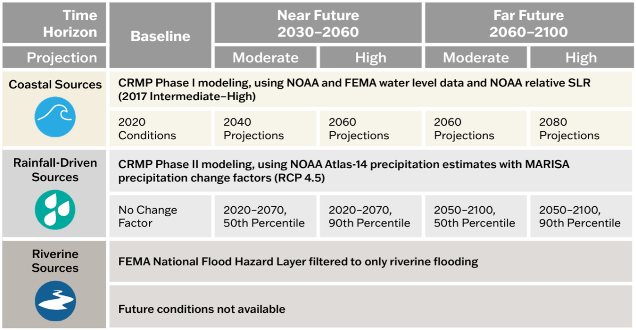
Varies by flood source and planning scenario. See reference figure for more information.

Shared Socioeconomic Pathway 2-4.5 (SSP2-4.5). “Moderate” scenario based on median (50th percentile) values and “higher” scenario based on 83rd percentile values.

 Resolution

10-foot

10-meter (~33-foot)  

Source

DCR with underlying data from the United States Army Corps of Engineers, the National Oceanic and Atmospheric Administration, and the Federal Emergency Management Agency.

Fathom

Access

View and download data and methodology documentation via DCR’s Flood Resilience Open Data Portal.

View the 1 in 100- and 500-year data for baseline conditions via DCR’s Flood Resilience Open Data Portal.

Access to all other products is provided to VA public institutions.*

Thông Tin Thêm

Learn more via the one-pager.

Learn more via the one-pager.

*Virginia government entities and state-recognized Tribal governments may sub-license all Fathom data from DCR for a 12-month renewable license term. To inquire about a sub-license agreement, including data use limitations, please contact us at flood.resilience@dcr.virginia.gov.

Other flood data

Additional data to visualize and understand flood hazards is available through state and federal platforms. Below is a snapshot of these data resources which can be accessed through the links provided.

  • FEMA Flood Hazard Data via DCR’s Hệ Thống Thông Tin Nguy Cơ Lũ Lụt Virginia (virginia Flood Risk Information System) (VFRIS) – VFRIS compiles and displays flood hazard data from the Federal Emergency Management Agency (FEMA) including Special Flood Hazard Areas. It also provides access to links to download FEMA Flood Insurance Studies, FEMA HEC-RAS Models. These maps also display non-regulatory flood hazard data including data from  and data do not incorporate future-looking projections based on changing precipitation patterns, new development or compound flood risk from tidal flooding events.

  • National Hurricane Center’s Storm Surge Risk Maps – includes data viewers and data downloads based on modeling which forecasts the extent and depth of storm surge resulting from hurricanes (category 1-5) for the Virginia coast. 

  • NOAA 2022 Sea Level Rise Technical Report – provides nationwide forecasts for sea level rise through 2150. The report provides more recent forecasts than were included in DCR’s coastal resilience web explorer and Phase I of the Coastal Resilience Master Plan. NOAA’s Sea Level Rise Viewer allows users to map and download the data.

  • NOAA Mid-Atlantic RISA Projected IDF Curve Data Tool – county-level tool for forecasting changes in precipitation depths from historic ATLAS-14 modeling to two future conditions (2020-2070 and 2050-2100) under two emissions scenarios (RCP 4.5 and RCP 8.5). The model forecasts precipitation change across six average recurrence intervals (2-year to 100-year) and 14 durations (5 minute to 7 day).

Tools for Planning

There are many tools to aid organizations in crafting a flood resilience plan. Below is an abbreviated list of useful planning tools. Additional tools can be found on the information gateways linked below.

Tools specific to Virginia

The following tools were developed with Virginia-specific needs in mind. While some are focused on exploring flood resilience specifically, others support resilience planning more broadly.

  • CFPF Resilience Plans - a DCR-approved Resilience Plan is required for localities submitting applications in the "project" category of the Community Flood Preparedness Fund. The requirements for an approved resilience plan can be found in Appendix F of the CFPF Grant Round 6 draft manual.
  • ADAPT VA – an information gateway on climate change adaptation for individuals, local programs, and agencies in Virginia. The website provides a variety of resources such as short and long-term sea level curves and maps, flood mapping and decision-support tools, legal and policy resources, and stories that explain adaptation through maps and pictures.
  • Proactive Planning for Resilience: Protocols for Community-Led Climate Adaptation Planning in Virginia – a Virginia-specific guide for climate adaptation planning for decision-makers across the Commonwealth. The website outlines steps for developing a plan, with detailed case studies, definitions, tools, legal considerations and best practices.
  • The RAFT and PREP Tool – The Resilience Adaptation Feasibility Tool (RAFT) Team is a Virginia state university partnership which brings capacity building and technical assistance to local governments over a period of 18 months to help build their resilience. Their team’s PREP Tool provides access to the RAFT’s methods and approach for assessing local government capacity for resilience and identifying and prioritizing projects to implement.

Federal Tools

Federal agencies have developed tools to assist organizations to plan and implement successful flood resilience strategies. The following resources may help you to craft your resilience plan.

  • US Climate Resilience Toolkit – a national portal that includes a variety of tools for building resilience to flooding impacts, including the Steps to Resilience Framework, which outlines a straightforward process for creating a resilience plan alongside resources to use to get there.
  • USACE’s International Guidelines on Natural and Nature-Based Features for Flood Risk Management – consolidates best practices for constructing natural and nature-based features for flood risk management into a guidance document for decision-makers and practitioners to use when considering these practices in flood resilience plan development.
  • US DOI Nature Based Solutions Roadmap – outlines information on nature-based solutions, including specific strategies, considerations for implementation, co-benefits, examples, and resources.

Cổng thông tin

These portals and databases contain a variety of resources – such as data, planning tools and funding information – that may be useful to your organization as you develop your resilience plan:

  • Thư viện tài nguyên phục hồi và khả năng phục hồi của FEMA
  • Association of State Floodplain Managers’ Library
  • Quỹ Động vật hoang dã quốc gia, Cơ sở dữ liệu tài trợ các giải pháp dựa trên thiên nhiên

Tài trợ cho việc lập kế hoạch và thực hiện

Organizations developing flood resilience plans should consider approaches which align both with DCR’s flood resilience plan guidance, as well as with federal resources and funding opportunities. Resources to help you understand how to align your approach to resilience planning with available funding resources include:

DCR Flood Resilience Funding Resources

DCR administers the Community Flood Preparedness Fund (CFPF) and the Resilient Virginia Revolving Fund (RVRF).  For more information on these funds visit the DCR Floodplain Management, Flood Resilience Funding website.
Beyond the DCR administered resilience funds, the Coastal Resilience Web Explorer Funding Opportunities tab provides an inventory of funding sources that may be available to finance the development and/or implementation of your plan. While it is catered to the coastal region, non-coastal activities may be eligible for some listed opportunities.
The DCR Flood Resilience Funding Geographic Focal Area Viewer identifies geographic areas that are designated as either required or preferred for resilience funding, including Low-Income Geographic Areas for the DCR Community Flood Preparedness Fund.

Other Funding Resources

  • Cơ quan Quản lý Tình trạng Khẩn cấp Liên bang (FEMA) và Sở Quản lý Tình trạng Khẩn cấp Virginia (VDEM)
    • Hướng dẫn hỗ trợ giảm thiểu nguy cơcủa FEMA
    • Thông tin chương trình tài trợ VDEM
    • Kế hoạch giảm thiểu nguy cơ COVA
  • Quân đoàn Công binh Lục quân Hoa Kỳ (USACE)
    • Flood Risk Management Mission to learn more about the Corps’ available assistance programs.
    • Division and District Information to determine the appropriate point of contact to learn more.  USACE is broken into watershed-based divisions and districts.
  • Others
    • American Flood Coalition Flood Funding Finder
    • U.S. Climate Resilience Toolkit Funding Resources

Báo cáo

Các báo cáo lịch sử có liên quan đến kế hoạch phòng chống lũ lụt ở Virginia được lưu trữ thông qua menu thả xuống bên dưới.

2025 Khả năng phục hồi trong Cập nhật trạng thái Khối thịnh vượng chung Virginia

Trong phiên họp Đại hội đồng 2024, Dự luật Hạ viện 1458đã sửa đổi các yêu cầu về Báo cáo Khả năng chống chịu lũ lụt trong Bộ luật Virginia (§ 2.2-220.5) bao gồm tình trạng khả năng phục hồi tổng thể trong Commonwealth, bao gồm khả năng chống lũ lụt. Được phát hành vào tháng 7 2025 và hai năm một lần sau đó, báo cáo bao gồm tình trạng các hành động được thực hiện bởi Giám đốc Khả năng phục hồi và các cơ quan nhà nước liên quan đến phối hợp và lập kế hoạch khả năng phục hồi và tất cả các khoản tài trợ phục hồi mà Commonwealth nhận được và phân phối trong hai năm trước đó.

Đọc Bản cập nhật trạng thái về khả năng phục hồi2025 trong Commonwealth of Virginia

2023 Resilience Coordination Working Group Report

Trong phiên họp Đại hội đồng 2024, Dự luật Hạ viện 1458đã sửa đổi các yêu cầu về Báo cáo Khả năng chống chịu lũ lụt trong Bộ luật Virginia (§ 2.2-220.5) bao gồm tình trạng khả năng phục hồi tổng thể trong Commonwealth, bao gồm khả năng chống lũ lụt. Được phát hành vào tháng 7 2025 và hai năm một lần sau đó, báo cáo bao gồm tình trạng các hành động được thực hiện bởi Giám đốc Khả năng phục hồi và các cơ quan nhà nước liên quan đến phối hợp và lập kế hoạch khả năng phục hồi và tất cả các khoản tài trợ phục hồi mà Commonwealth nhận được và phân phối trong hai năm trước đó.

  • Tải xuống Báo cáo cuối cùng và các khuyến nghị của Nhóm công tác điều phối khả năng phục hồiđầy đủ
  • Tải xuống Bản tóm tắt các khuyến nghị cuối cùng của Nhóm công tác điều phối khả năng phục hồi

Trung tâm Chính sách Công (CPP) của Đại học Thịnh vượng chung Virginia (VCU) đã hỗ trợ RCWG với sự hỗ trợ tài chính từ Trung tâm Phục hồi Lũ lụt Thường xuyên Thịnh vượng chung (CCRFR).

2023 Báo cáo tình hình khả năng chống chịu lũ lụt

Vào 2023, Giám đốc Khả năng phục hồi của Khối thịnh vượng chung đã công bố báo cáo hai năm một lần gửi Thống đốc và Đại hội đồng về tình trạng khả năng phục hồi lũ lụt tại Virginia theo Bộ luật Virginia (§ 2.2-220.5).

Đọc Báo cáo tình trạng chống lũ lụt2023 .

Trang chủ » An toàn đập và quản lý đồng bằng ngập lụt » Lập kế hoạch chống chịu lũ lụt
Sở Bảo Tồn và Giải Trí Virginia (Virginia Department of Conservation and Recreation)
600 East Main Street, tầng 24| Richmond, VA 23219-2094 | 804-786-6124
Please send website comments to web@dcr.virginia.gov
Address general inquiries to pcmo@dcr.virginia.gov
Copyright © 2026, Virginia IT Agency. All Rights Reserved
Last Modified: Wednesday, 21 January 2026, 10:38:47 AM
Báo cáo minh bạch eVA Xem các khoản chi tiêu của Sở Bảo Tồn và Giải Trí Virginia.
Liên hệ | Trung Tâm Truyền Thông | Chính sách Quyền riêng tư | Thông báo theo Đạo Luật Người Mỹ Khuyết Tật (ADA) | FOIA | Việc làm | Bộ Quy Tắc Đạo Đức (PDF)
Biểu Đồ Tổ Chức DCR (PDF) | Kế Hoạch Chiến Lược (PDF) | Báo Cáo Tiến Độ Hành Pháp (PDF) | An Toàn Công Cộng & Thực Thi Pháp Luật